Magnitude 4.9 Earthquake Mapped Using Sentinel-1 SAR Data Processed on NASA’s HyP3 Platform
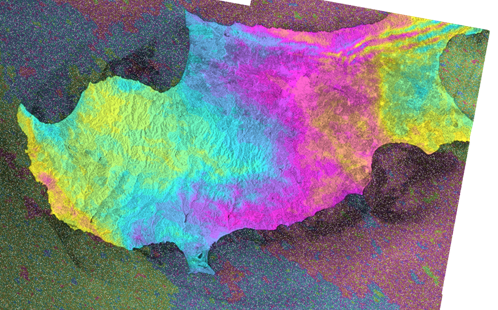
A magnitude 4.9 earthquake struck 16 kilometers from Paphos, Cyprus, at 12:29 AM on September 4, 2024, in a close proximity to the “Tombs of Kings” case study of the project. Using data from Sentinel-1 Synthetic Aperture Radar (SAR) imagery, detailed ground deformation caused by the earthquake has been mapped. The data, processed on NASA’s HyP3 platform, provides mapping ground displacements into the seismic shifts in the affected region.
The analysis compares satellite images from August 25, 2024 (before the earthquake), with those from September 6, 2024 (after the event). The interferogram produced from these images clearly highlights the areas where the terrain was altered by the earthquake. This analysis aids in understanding the full extent of the earthquake’s impact.
The Sentinel-1 SAR images, processed via NASA’s Earth Observing System Data and Information System (EOSDIS), demonstrate the value of satellite-based radar in tracking ground movement and helping authorities assess damage and risks following natural disasters.
The HyP3 platform streamlines the processing of these data, enabling rapid access to vital Earth observation information.